Mapping 19th-century American Regional English
Linguists have accomplished a great deal in the way of delineating and describing regional varieties of American English in the twentieth century. But how far back can we trace these regional differences? What is Southern? What is Northern? How has American English changed in the last century and a half? We have started exploring these questions by searching for distinctive words, usages, and grammatical forms that are frequent enough to be significant, forms that we can be reasonably sure are representative of the language of speakers from one part of the country or another, or shared by two or more regions, or, in some case, typical of American English in general in the mid-nineteenth century.
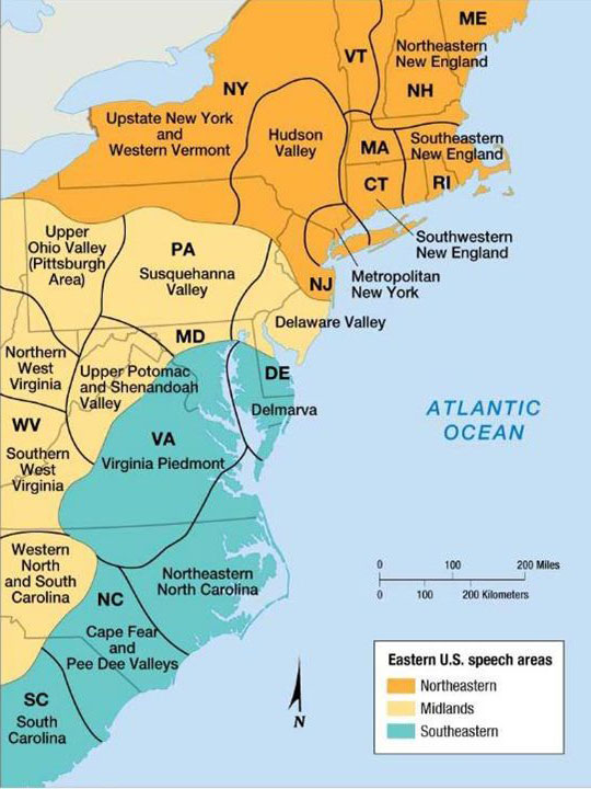
In his 1949 Word Geography of the Eastern United States (WGEUS), Hans Kurath introduced his influential three-part division of American dialects. Kurath argued that the dialects of the states along the eastern seaboard represented three distinct primary speech areas: the North, the Midland, and the South.1 The border between the North and the Midland begins on the coast of New Jersey, then moves northwesterly direction into Pennsylvania before turning west through the northern part of the state and into Ohio. The border between the Midland and South begins on the coast of Delaware, then moves westward before snaking its way in a southwestwardly direction through Virginia before turning directly south into North Carolina before turning westward through the South Carolina highlands. [insert our map North, Midland, South] In Kurath’s model, each of these three primary speech areas are subdivided into smaller regions (e.g., Northeastern New England, Southeastern New England, etc.) For our project, an important distinction is the theoretical border between the North Midland and the South Midland. The South Midland includes the western parts of Virginia, all of West Virginia, the western half of North Carolina, the upland parts of South Carolina, all of Kentucky and Tennessee, the northern parts of Georgia. Alabama, and Mississippi. It may also extend into the southernmost parts of Ohio, Indiana, and Illinois. Although Kurath’s three-part division remains an influential model, others have argued that the primary distinction is two-part, North and South, and sometimes prefer Upper South instead of South Midland. As our maps will demonstrate, both the three-part and two-part models of primary dialect areas have some validity for mid-nineteenth-century America. See the Regional Features section for examples.
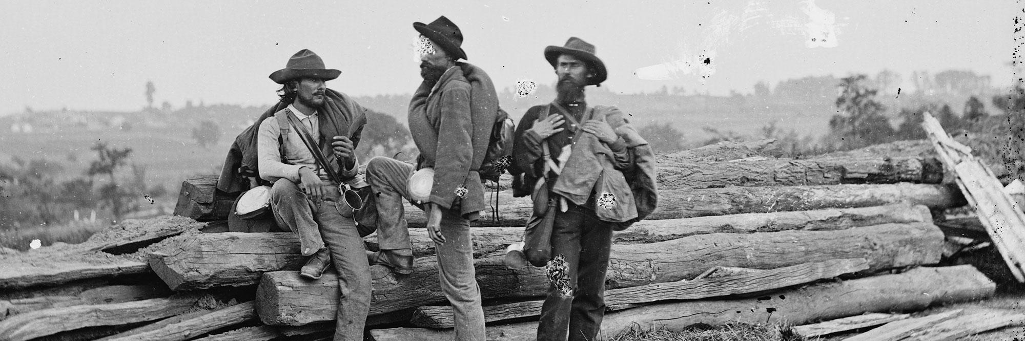
The Word Maps section explores regional varieties of American English by using maps, accompanied by entries briefly defining the meaning or usage and illustrative quotes taken directly from the letters. The maps show the places of residence of the letter writers included in the mapping part of the project.2 We have not included writers who wrote a single letter. North Carolina is the best represented state and accounts for about a third of the 6,216 Southern letters searched. Of states east of the Mississippi River, West Virginia, Maryland, and Delaware are underrepresented in the sample. Most states west of the Mississippi are also underrepresented at present. Altogether, 6,207 Northern letters were searched.3 Although the totals for the Northern and Southern states are very close, the North remains underrepresented given the number of Northern soldiers who served in the war and the populations of the Northern states. There are fewer letters written by women than men, mainly because of the difficulty soldiers had preserving letters from home, particularly when they were in the field. As a group, African Americans are underrepresented at present.
Since American English in general has changed so much since the 1860s, it is also important to explore what was general in American English. For example we have included a map and entry for haint, a feature common throughout the country in the 1860s. Other widespread features include a-prefixing of present participles (agoing, agetting), plural was (we was, they was), and shall with first-person subjects (I shall, we shall) instead of the widespread use of will for all persons, at least in informal speech. The Midland seen (instead of saw) for the past tense of see spread far and wide, including the South. So did the Scotch-Irish preposition and conjunction against/ agin meaning “by, before, by the time.” The Pennsylvania German preposition and conjunction till, also meaning “by, before, by the time,” was also carried southwestward out of the Midland hearth, although it never became as common or widespread as against/ agin and was restricted to letter-writers of Pennsylvania German ancestry.
The mapping part of the CACWL project differs from most other linguistic atlas projects in that has no questionnaire. Although we have been guided by the data collected by the linguistic atlas publications, as well as by the Dictionary of American Regional English and other dictionary sources, we can only collect and record what we find in the letters themselves.4 The evidence CACWL has gathered shows that American English and its regional varieties have continued to evolve and change over the last hundred and fifty years. Words and usages that were once widespread and common have since become more geographically restricted, have declined in popular use, or in some case have disappeared entirely. The term pap for father was once much more widespread and common in the Midlands and South than daddy. Southerners frequently used the noun connection in reference to relatives beyond the immediate family, a usage much more common than kin or kinfolk. Soldiers from western North Carolina used the term slips for men’s underpants or drawers, a usage not recorded in any of the dictionary sources consulted. Other words, once restricted regionally are now widespread. Baked beans, for example, can now be found on any supermarket shelf through the country, but in the 1860s was restricted to New England, especially eastern New England. Apple butter was a distinctively Midland term which spread westward and southwestward from Pennsylvania. For constructing our maps we have searched especially for high-frequency words and features, especially those which are characteristically regional. Clearly, the letter writers we have used were not inhibited by prescriptivism and prohibitions against “vulgar” and “provincial” usages. Letter writers, whether they were soldiers or the folks at home were writing to those who spoke as they did.
Notes
1 For more information on American regional dialects see Atwood, E. Bagby. 1953. A Survey of Verb Forms in the Eastern United States. Ann Arbor: University of Michigan Press. Carver, Craig M. 1987. American Regional Dialects, A Word Geography. Ann Arbor: University of Michigan Press. Dakin, Robert F. 1966. The Dialect Vocabulary of the Ohio River Valley: A Survey of the Distribution of Selected Vocabulary Forms in an Area of Complex Settlement History. PhD dissertation, University of Michigan. DARE. Dictionary of American Regional English. 1985-2013. Edited by Frederic G. Cassidy, John Houston Hall, and Luanne von Schneidemesser. 6 vols. Cambridge, Mass.: Belknap Press of Harvard University Press. Kretzschmar, William A., Virginia G. McDavid, Theodore K. Lerud, Ellen Johnson. 1994. Handbook of the Linguistic Atlas of the Middle and South Atlantic States. Chicago: University of Chicago Press. Kurath, Hans. 1949. A Word Geography of the Eastern United States. Ann Arbor: University of Michigan Press. Kurath, Hans and Raven I. McDavid, Jr. 1961. The Pronunciation of English in the Atlantic States. Ann Arbor: University of Michigan Press. Pederson, Lee, Susan L. McDaniel, and Carol M. Adams, eds. 1986-1993. Linguistic Atlas of the Gulf States. 7 vols. Athens, Georgia: University of Georgia Press. There are numerous online resources including some that include Kurath’s 1949 map. Also of interest are the Linguistic Atlas Project at the University of Georgia and TELSUR Projects at the University of Pennsylvania.
2 Our maps are based on the Ensign, Bridgman, and Fanning 1856 Railroad Map of the United States downloaded from the Library of Congress website. After experimenting with many other maps, we decided on this one not only because it is very detailed, but also because it proved the best for inserting symbols representing letter writers’ places of residence. Moreover, because it is a railroad map, it suggests both relative population densities as well as the degree of industrialization in various parts of the country.
3 Of the Northern letters 4,397 have been transcribed and an additional 1,810 have been searched. We have also photographed or photocopied transcripts of letters at libraries and archives, in cases in which the originals are not available and in which the transcripts are judged to be reliable. So far we have used relatively few published sources and, once again, only when the transcription they contain are judged to be reliable. Among these are some from university presses including, for example, Freedom, A Documentary History of Emancipation, 1861-1867, Series II, The Black Military Experience, edited by Ira Berlin, et al., Cambridge: Cambridge University Press, 1982; The Confederacy is on Her Way Up the Spout: Letters from South Carolina, 1861-1864, edited with commentary by J. Roderick Heller III and Carolyn Ayres Heller, Athens: University of Georgia Press, 1992; and An Uncommon Soldier, The Civil War Letters of Sarah Rosetta Wakeman, alias Private Lyons Wakeman 153rd Regiment, New York State Volunteers, edited by Lauren Cook Burgess, New York: Oxford University Press, 1994. We have also used a few collection published by descendants of soldiers. Example of these include Letters of a Confederate Private, Thomas O. Wilson, Company F, 51st Virginia Infantry, Whorton’s Brigade, edited by James F. Wilson. Blacksburg, Virginia: Pocahontas Press, 2004 and Letters of William F. Wagner, Confederate Soldier, edited by Joe M. Hatley and Linda B. Huffman, Wendell, North Carolina: Broadfoot’s Bookmark, 1983. Typically, books of these kind contain at least one image of a letter which can be compared to the transcription of the letter. We have also searched a large collection of transcribed letters from the Valley of the Shadow Website, the Demus and Christy Families, African-Americans from Franklin County, Pennsylvania.
4 See especially Michael Ellis. 2016. “Mapping Southern American English, 1861-1865.” Journal of Linguistic Geography 4.1: 1-14. Other publications resulting from the project include: Michael Ellis and Michael B. Montgomery. 2011. “About all: Studies in Nineteenth-Century American English I.” American Speech 86.3: 340-354; Michael Ellis and Michael B. Montgomery. 2012. “LAMSAS, CACWL, and the South-South Midland Dialect Boundary in Nineteenth-Century North Carolina.” American Speech 87.4: 470-490; Michael Ellis. 2013. North Carolina English, 1861-1865, A Guide and Glossary. Knoxville: University of Tennessee Press; Michael B. Montgomery, Michael Ellis, and Brandon Cooper. 2014. “When did Southern American English really begin?” In The Evolution of Englishes. The Dynamic Model and Beyond, edited by Sarah Buschfeld, Thomas Hoffmann, Magnus Huber and Alexander Kautzch, 331-348. Amsterdam: John Benjamins.
NEXT: Regional Features